
Techniques > Sites > HM Trawler Elk
Site: Mapping the Armed Trawler Elk (1940)
Techniques: Photomosaic, Metal wreck


|
The wreck of the trawler Elk lies in 30m depth in the entrance to Plymouth Sound, England, and is regularly visited by sports divers.
The 33m long side trawler Elk was built in 1902 by Cook, Welton & Gemmel Ltd. at Beverley near Hull in the north of England. Side trawlers have the trawl nets deployed over the side with the trawl warps or wires passing through blocks suspended from a set of gallows forward and a set aft. The small wheelhouse was mounted aft over the 62 hp triple expansion steam engine, with the cylindrical coal-fired boiler in front. The Elk was hired by the Admiralty as a danlayer at the start of WWII becoming HMT Elk (FY 4.24) with captain J. S. Bush RNR in command and armed with one 6 pdr gun. After just one year of service the Elk was sunk by a mine off Plymouth on 27 November 1940 but fortunately all of the crew were saved. See HMT Elk on the SHIPS Project web site...
The wreck was reported to have been located in 1977 but did not appear on an Admiralty survey until 1982 where she was described as having superstructure sheared away with no obstructions above hull level. The remains of the Elk were found still upright on a sandy seabed, largely complete but missing the deck superstructure, deck and masts, some of which lie on the seabed on the port side. The stern counter has been pushed upwards and forwards suggesting the ship landed stern first on the seabed.
The site has been slowly disintegrating since the time it was first found but in the last few years the decay has got much faster with the deck plating almost all gone and the hull plating now much thinner. The small foredeck at the bow where the anchor windlass could be seen has recently collapsed into the forward compartment (Fig. 2).
Click on any small image below to show a larger version.
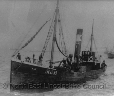
Fig 1: The Elk trawler (GY1235) (NE Lincolnshire Council)
Survey Aims
The SHIPS Project have been recording all of the known shipwrecks near Plymouth as part of a wide-ranging study of the maritime heritage in the area. One of the tasks has been to produce plans of the local shipwrecks that can be given to divers to help them understand and appreciate these historic sites.
Aim of this exercise was to create a deck plan of the Elk wreck for divers so they can identify features on and within the hull. The sides of the ship lie low to the seabed and are largely featureless so a 3D model was not required.
The site is in 30m so time available on site is short and it is often dark on the wreck with visibility around 4-5m.
Method
Only a very simple plan of the wreck site was required so simple recording and surveying methods were used, these include sketching, offset measurements and a photomosaic and video of the detailed areas.
Plans of a similar vessel built in the same shipyard were used as a starting point for the overall hull shape. The plans were scanned to a digital image then imported as a basemap into Site Recorder, scaled using the known measurements of the hull and the outline converted to a line drawing. The dimensions of the Elk's hull were checked at known points against the drawing to ensure that the digitised hull shape was accurate.
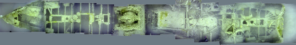
The photomosaic was created from a series of overlapping photographs taken straight downwards with the camera kept at a constant height of 3m above the ship's deck. The images were then joined together in Photoshop to produce a single seamless image showing the view from above the wreck looking down. The visibility underwater limited how far above the wreck the diver could take photographs which then limited the width of the wreck that could be captured in one pass. As time was short only the centreline of the vessel was recorded but this did capture all of the detail as the sides of the ship where the deck meets the bulwarks had no significant features that needed to be recorded.
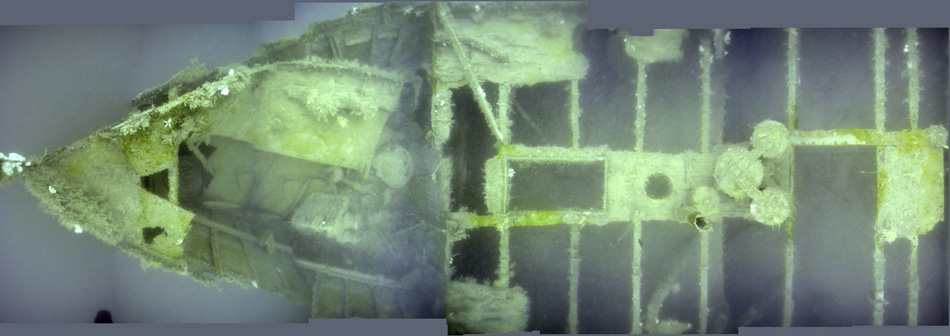
Fig 2: Photomosaic of the bow of the Elk
The photomosaic was made using a Nikon D5200 DSLR camera with an 11mm rectilinear wide angle lens. Using the wide angle lens allowed the photographs to be taken close to the hull as it was necessary to minimise the amount of water between the camera and the wreck to overcome the poor visibility. Natural lighting was used to avoid the deep shadows and backscatter problems that can occur when using strobe lights. The waterproof camera housing was also fitted with a small bubble level on the back so the diver could make sure the camera was pointing straight downwards.
The photomosaic was imported into Site Recorder and scaled to fit the digitised drawing outline. Separate measurements of significant features such as the length of the boiler were used to check that the mosaic was scaled to the correct size.
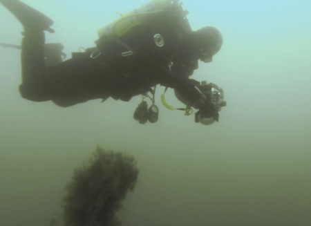
Fig 3: Diver taking photographs for the photomosaic

Fig 4: Digitising the photomosaic in Site Recorder; Plating and deck beams, details and background
The deck plating shown on the mosaic was digitised first with the deck beams drawn underneath (Fig. 4A).
Deck and beams were drawn on separate layers in SR4 to make it easy to change the colour of all of them at the same time when choosing the final colour scheme for the site plan. Details such as the trawl winch, boiler and engine were added next, again on a separate layer so they could be highlighted in a different colour on the plan. The overall hull shape was coloured to be darker to make the deck plating, details and deck beams stand out producing the final plan (Fig. 4C).
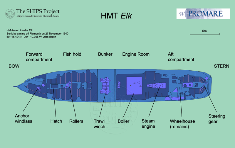
Fig 5: The finished site plan of HMT Elk
Finally the labelled plan could be created (Fig. 5). The finished site plan was printed from Site Recorder as a high resolution A2 size PDF then exported from Adobe Acrobat as a TIFF image. Adobe Photoshop was used to add the background colour, labels, text and logos.
The photomosaic could be created using a compact digital camera rather than the expensive DSLR as far more detail was recorded in the photomosaic than was needed for the site plan. The wide angle lens on the DSLR allowed more of the width of the ship to be recorded in one run so the same record with a compact would make a narrower strip or two runs would be required. The compact camera may also produce pictures with more distortion than the DSLR but often the distortion can be removed in Photoshop.
Related Pages
- Photomosaics
- Sketching