New Techniques Guide:

3H Consulting Supports:
 |
|---|
 |
Site Recorder
Software, Training and Consultancy
for Maritime and Foreshore Archaeology
 |
|---|
 |
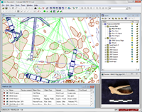
Site Recorder Software:
Site Recorder 4 is versatile data management software designed for use on maritime and intertidal archaeology projects. Site Recorder 4 is powerful, practical and used on projects all over the world. The program has been designed by archaeologists for archaeologists so you don’t need to be a computer expert to use it.
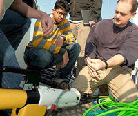
Training:
We provide training to the archaeological community in wreck recording, project management and marine geophysics.
Site Recorder Software Key Uses:
- Maritime and underwater archaeology
- Shipwreck surveying and recording
- Fieldwork planning
- Electronic publication
- Shipwreck GIS
- Project and data management
- Cultural resource management
Consultancy, Training and Media Support
- Project management and consultancy
- Shipwreck location and identification
- Marine geophysical surveys
- Deep water expertese and experience
- Research and evaluations