

|
Techniques > Sites > Mary Rose
Site: Excavating the Mary Rose (1545)

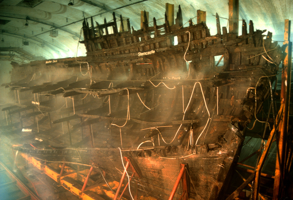
The Mary Rose was one of the first ships built during the early years of the reign of King Henry VIII, probably in Portsmouth. She served as Flagship during Henry’s First French War and was substantially refitted and rebuilt during her 36 year long life. The Mary Rose sank in 1545 whilst defending Portsmouth from the largest invasion fleet ever known, estimated at between 30,000 and 50,000 individuals and between 150 and 200 vessels. This number is nearly twice the number estimated within the fleet of 1588, latterly known as the Spanish Armada. At this time Mary Rose was the second largest and most heavily armed vessel within the fleet; she carried 91 guns deployed over three decks, her main gun deck carried fourteen large guns including two cannons which fired 64lb cast iron shot. The Mary Rose marks a transition between the use of a vessel to support guns and a vessel built to carry large guns close to the waterline, her structure is undocumented in historical sources and there are no shipwright’s plans. The Mary Rose is an extremely important vessel to study in order to understand the evolution of the fighting ship.
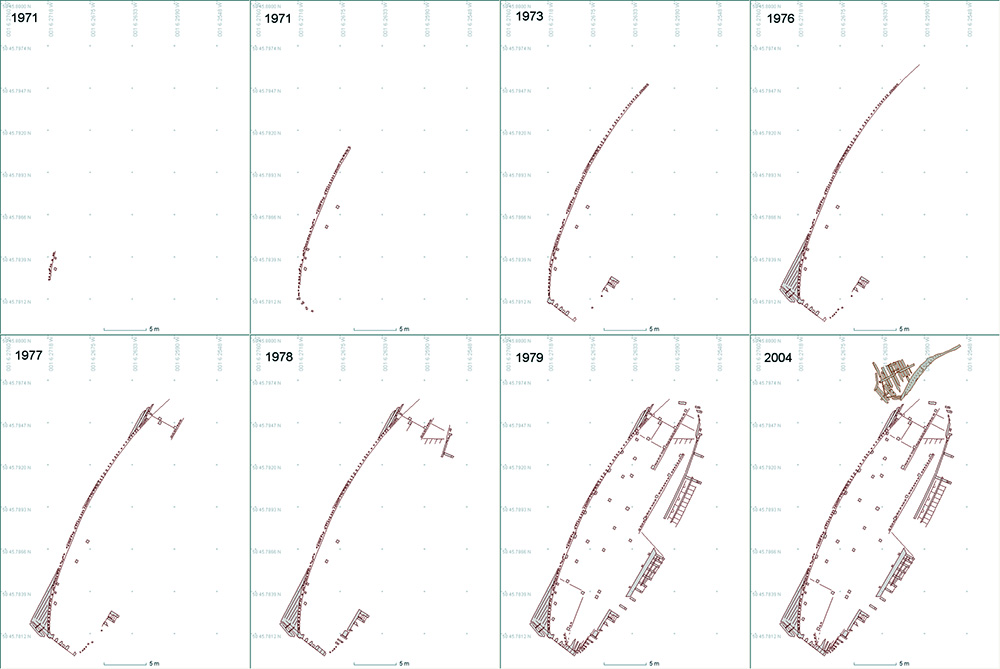
In 1965 Alexander McKee started Project Solent Ships and one of the wrecks they hoped to find was the Mary Rose. In 1967 pioneering sidescan and sub-bottom survey work by EG&G and Doc Edgerton found a ‘flattened W’ shaped target in the area where the ship was thought to have sunk. The years 1968-1971 were spent by ‘Mad Mac’s Marauders’ finding proof of the ship's identity with few funds and little resources, success was achieved in 1971 with the discovery of the first three of the ship's frames.
Excavation work between 1979 and 1982 took 28000 dives and 12 man years on the bottom but culminated in the recovery of a large part of the starboard side of the hull. The recovery itself was shown on live television and was watched by 60 million people worldwide. At that time it was not known that site was not fully excavated and a portion of the bow remained under the mud of the Solent.
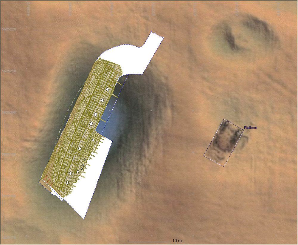
The UK Ministry of Defence may need to widen and straighten the channel approach to Portsmouth Harbour to accommodate their new aircraft carriers. The dredging work could affect the site of the Mary Rose historic wreck so what remains on the site had to be removed. When the hull of the Mary Rose was recovered from the seabed some of the ship was not recovered, some timbers and artefacts were reburied while the remains of the bow castle were never investigated. A multi-phase project was put together by the Mary Rose Trust with the aim of recovering the buried artefacts and debris, excavating the spoil mounds to remove any artefacts, undertaking visual and magnetic searches and delimiting the extent of the debris field.
The fieldwork for 2003 included using an excavation Remotely Operated Vehicle (ROV) to remove the top layer of silt that had covered the wreck leaving the delicate excavation to be done by divers with airlifts. Site Recorder was used for mapping, finds recording and providing decision making information for the archaeological director, Alex Hildred. A Sonardyne Fusion Acoustic Positioning System (APS) was used on the four week project to provide high accuracy positioning for support vessel, ROV and divers. The positioning system was connected to Site Recorder which allowed it to display the positions of divers on the site plan in real time as they moved around the site.

|
 |

|
|

|
|
|
|
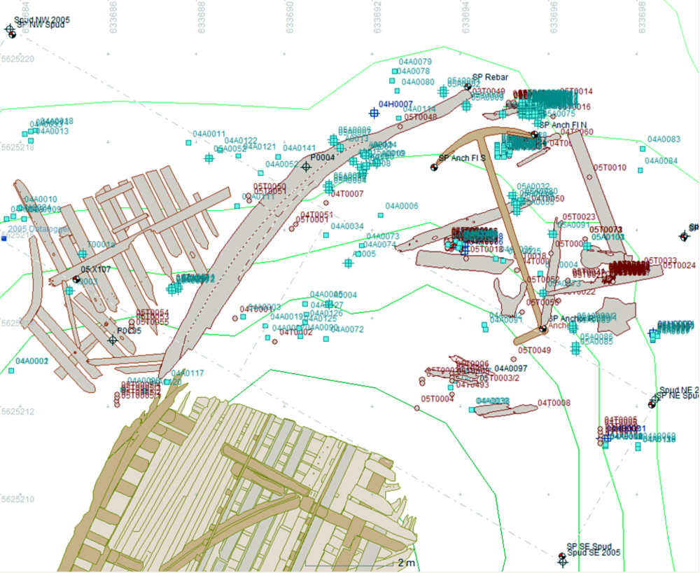
At the end of the 2003 season the first evidence of the remaining bow structure was found, a 5m long section of stem timber. The mission for 2004 was to investigate the size and condition of the remaining timbers in this area, in association with the stem timber were sections of articulated port side lower hull timbers including partial remains of inner (ceiling) planking, frames and outer hull planking. A 5m long anchor was also located.
Recovery
More timbers were uncovered to the north of the stem timber. The area around and under the anchor was investigated and further timbers were found there, including what may be a floor timber which would have come from beyond the end of the keel. To the east of the anchor some concretions were uncovered – including a breech chamber and a hook and bronze pulley sheave which may have formed part of the anchor-handling equipment.
The stem timber was stropped up to a 7 metre long spreader beam and was gently lifted from the seabed using a crane. The stem was transferred underwater onto a cradle ready for its final journey to the surface and ashore to Portsmouth. Similarly, the anchor was moved from its resting place to be alongside the cradle before raising.
The final task was to put the site to bed. The excavated area has been covered with an industrial geotextile called ‘Terram’, which has been held down by 800 sandbags and 100 tons of sand. This should ensure the preservation of the area uncovered by the last two seasons of excavation and keep the site safe for future generations
Technology
The divers used standard surface supplied diving equipment including voice communications along with helmet mounted lights and video cameras. The divers could also use a 'survey staff' fitted with an acoustic positioning system for positioning finds and structure. On board the support vessel it was possible to see the pictures from the cameras and to hear the discussion between divers and dive supervisor. The recording and positioning systems were set up behind the dive supervisor so the recorder could see the feed from the cameras and the positions of the divers on site whilst adding information to the Site Recorder GIS. The archaeologists and divers could collectively discuss issues and ideas as they occurred with all the available information at their fingertips.
The results from this project show that the Fusion Long Baseline acoustic positioning system can be used to achieve high accuracy positioning underwater on an archaeological site. The system can achieve this even in the difficult acoustic environment found in tidal water only 10m deep. The 30mm position accuracy achieved on this project is comparable to conventional survey methods and is sufficient for plotting finds and the extent of hull structure.
Bibliography
- Kelland N. & Holt P., 2014, Surveying, Excavating and Raising the Mary Rose, Sonardyne International Ltd.
-
Hildred A. (ed.), 2011, Weapons of Warre: The Ordnance of the Mary Rose, Mary Rose Trust Ltd., ISBN-10: 0-9544029-3-6, Contributor
-
Rule M., 1982, The Mary Rose, Conway Maritime Press Ltd., ISBN 0 85177 289 7
-
Marsden P., 2003, Sealed By Time, Mary Rose Trust Ltd., ISBN 0 9544029 0 1
-
Hildred A. & Holt P., 2004, Acoustic Technology in Historic Wreck Recovery, ©Hydro International March 2004 Vol 8 No 2