
Site Recorder 4 Tour: Finds Handling and Associations
Back | Tour Start | Next
As well as being a fully featured GIS program, Site Recorder 4 is also a finds handling spatial database. Site Recorder 4 is unlike other finds programs that use databases such as Access and FileMaker Pro as it integrates the finds information along with finds drawings and location information. This means that finds can be shown on the site plan in position and as part of a proper in-situ drawing.
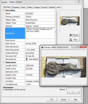
Finds are added to Site Recorder as 'Artefact' objects. Lists of artefacts can be displayed, sorted, filtered and printed allowing quick and easy reporting on items found or recovered. Information about each Artefact is recorded as a set of properties with sufficient detail to capture all the information required.
Some of the data recorded about each Find may need to be limited to a set of words or terms used by the project or the client. Site Recorder uses word lists to define the range of words that can be used for each property and includes tools for editing these lists.
Along with finds you can record information about samples relating to finds and sediments, features associated with or containing the finds as well as Sector objects for defining trenches or specific areas on the site. Artefacts, Features and Sectors can be associated with each other and this can be displayed in a graphical form as an aid to interpretation. Dive logs can be linked with Artefacts allowing you so quickly locate and view a dive log associated with the discovery or recovery of a find. Images, video clips and scanned drawings can also be linked with each find so you can readily retrieve any image associated with a find.
In-situ drawings of each find can be attached to each Artefact object so each find appears on the chart as it was found on the seabed. The finds themselves can also be positioned relative to survey points or baselines producing a 'live' site plan. Mistakes found in the survey data no longer require the site plan to be erased and redrawn or moved by hand - as the survey improves the finds automatically move to follow the survey points they are positioned with.
Site objects can be associated with each other providing extra information about the Site and how it was recorded. This provides a way of relating groups of objects found in the same area that have some meaningful relationship, building up a hierarchy of associations within the Site.
Sector objects are used to define areas of the site or seabed that are not Features. Trenches, groups of scattered finds or areas that have been investigated can all be represented using a Sector. Other Sectors, Features and Artefacts can be found within a Sector.
Feature objects can be used to represent such things as large concretions, areas containing particular deposits or the ‘ghost’ remains of a container that has long since disappeared leaving just the contents. A large concretion recorded as a feature may contain a number of Artefacts and other, smaller features.
Artefacts themselves can be associated with other Artefacts, either by containing them or simply by being close to them. The relationship between these objects gives clues about their use. Site Recorder allows these relationships to be recorded in a formal manner and provides tools to visualise them. The result is a hierarchical tree of relationships between Artefacts, Features and Sectors.
Back | Tour Start | Next